Real-Time 3D Inversion of Logging-While-Drilling Data
Offshore operators often struggle to navigate complex reservoirs where traditional seismic data lacks the resolution to "see" features smaller than 150 feet, and standard drilling tools only measure the immediate area around the wellbore. This leaves a critical gap in subsurface understanding that can lead to missed oil zones or drilling hazards. Working with Halliburton, CGI "broke down" this massive mathematical challenge by adapting advanced 3D inversion technology originally developed for the mining industry.
Our solution utilizes a proprietary finite-volume method on locally refined octree meshes to decouple global data into manageable, localized volumes. This enables full 3D resistivity models to be updated in real time—within the standard five-minute mud pulse telemetry window—using modest computational resources. By transforming ultra-deep resistivity measurements into high-fidelity 3D volumes, we help operators visualize 3D structures like meandering channels and complex fluid contacts that are invisible to 1D or 2D methods.
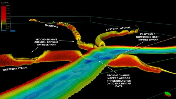
In a landmark application for Aker BP in the North Sea, CGI’s 3D inversion revealed the true shape and connectivity of erosive turbidite channels. This quantitative insight allowed the team to optimally land a trilateral well and identify bypassed hydrocarbons, significantly improving completion design and long-term production potential.